
THE BCH ARCHIVE
LOCAL HISTORY FOR
BIRTSMORTON
CASTLEMORTON
HOLLYBUSH
And The Surrounding District
CASTLEMORTON COMMON GUIDEBOOK
1. General Geology
Castlemorton Common has survived until the present time
because of its geological history.
Britain can be divided into 'Highland' and 'Lowland'
regions, by drawing a curved line from the mouth of the
River Exe in Devon, to the mouth of the River Tees in
Yorkshire. The Malvern Hills form part of this line,
and it is strange, but true, that even though the
highest point is only just over 1300 feet above sea
level, the next equal height due north east is the Ural
mountains of Central Russia, 4,000 miles away.
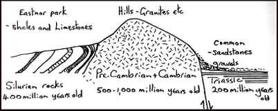
The rocks of the hill ridge are very ancient, being
pushed up into the earth's crust over 500 million years
ago, in the Cambrian period. These rocks were covered
by a sea in Silurian times, about 400 million years
ago, and later an earth movement, known as the
Cheltenham drive, pushed up the hills as a ridge,
whilst creating a fault along the eastern side. As the
sedimentary Silurian rocks were eroded, the hills were
left as a ridge by Triassic times about 200 million
years ago.
The climate of the Triassic period was that of as very
harsh desert. The Keuper sandstones were built up over
the landscape to the east of the hills, ie where the
common is now. Thus the scene was set, as shown in the
diagram.
During the Great Ice Age, which ended only about 10,000
years ago, an ice-sheet extended from the north down as
far as Gloucester, and the Malvern Hills probably stuck
up through as bare frost-shattered peaks.
When the ice—sheets began to melt, they deposited
glacial clay and boulders. However no deposits of
this clay have yet been found east of the hills, but
the whole area within a mile or two of them has
deposits of Malvernian gravels, especially thick in
some areas on the lower flanks of the actual hill
slopes. These gravels are basically all the frost-
shattered bits of rock, which were washed down by melt
waters or gradually crept down the bare hills under the
influence of gravity.
The Hill soil is too thin and acid, and the gravels are
difficult to cultivate being relatively infertile.
This fact led to the survival of the commons, the
more fertile soils of the river terraces being used in
preference and the area around the hills was left as
wilderness. The solid geology can be seen in the
Gullet quarry, and the gravels in the banks of the
stream in the middle of the common
By Med Snookes
A handbook for Locals and Visitors