
THE BCH ARCHIVE
LOCAL HISTORY FOR
BIRTSMORTON
CASTLEMORTON
HOLLYBUSH
And The Surrounding District
CASTLEMORTON COMMON GUIDEBOOK
2. Development and history of the Common
The main natural vegetation of Britain is forest, and after the Ice Age, the plants slowly returned, until
most of the country was covered in a blanket of trees,
but it was a blanket full of holes. So it was in this
area, when prehistoric man first arrvied, as a hunter,
and found the bare hill tops, and thick woodland, with
some clearings where the soil was too stony, or wet,
for trees to grow well. It is said that the name
Malvern comes from the Celtic Moel Bryn meaning
'bareheaded'.
As Britain was settled man made little impact upon the
area of the common, though there are Iron Age Hillforts
on the hills either side - British Camp and Midsummer
Hill, and the Romans built roads to the east and west.
The only marks of man from this long period may be the
ancient trackways across the waste, especially the old
hill crossing by Pink Cottage. The old hollow ways
leading from the car park by the Pink Cottage track, up
through the bracken and through the Pink Cottage gap
(which is called the Silurian pass in geological
circles) probably date from this period, but the
straight roads and tracks across the lower common, seem
to be from the Mediaeval period rather than the Roman.
William the Conqueror 'afforested' the Malvern Chase,
which means that in about 1086, an area which stretched
from the hills to the River Severn. and from Cowleigh
Gate (North Malvern) to Whiteleaved Oak (South end of
Ragged Stone Hill) was declared Royal Hunting Forest.
The wild land was good for deer, and wild boar and
other types of game. At some point during the next two
hundred years the powerful landlords of Westminster
acquired rights here, and in l2&l it is recorded that
the Abbey "assarted" some land at Castlemorton (to
assart means basically to enclose and sell off common
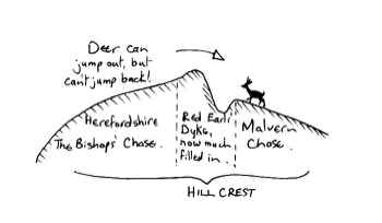
land). In the period soon after, the Red Earl,
Gilbert de Clare (l2A3-95), built his Red Earl's Dyke,
along the crest of the hills, to divide his Malvern
Chase from the Bishop of Hereford's Western Chase.
The Earl had a ditch and dyke constructed so that the
deer could jump into Malvern Chase, but could not jump
back out, as shown below:
The Chase was very thinly populated, and records are
correspondingly thin. In 1276 the taxed population of
the area was only 93! Only records of the old laws of
the Chase seem to have survived. These were very
harsh, and included maiming of dogs so that they could
not chase deer (to prevent poaching), and hanging law-
breakers at Rhydd Green near the river and at Hangmans
Hill below Pink Cottage.
In the l4th century this area was still very remote,
and was the scene for William Langlands epic poem of
Piers Plowman.
A small number of Castlemorton residents died during
the Plague in l609—lO but in general the population was
slowly increasing, usually through the growth of the
'squatter' settlements.
There was an old custom that, if a person could build a
house between sunrise and sunset, so that smoke was
coming out of the chimney, that person could claim any
land he had fenced around in the same time — quite a
tall order!
In practice a family would sneak off into a remote
valley in the Chase, and first build a chimney and a
quick rough shack in order to fulfil the first part of
the custom. Afterwards, especially if they were not
discovered for days, they would gradually enclose a
bigger piece of land especially the more fertile
valley-land.
As the family grew the sons and daughters would take
land adjoining the parental home, and thus the
settlement would spread up the valleys. This
'squatter-landscape’ can be seen in several valleys,
where the walker on the common suddenly comes up on a
scatter of dwellings, eg Eight Oaks, Huntsbridge, and
below Hollybush church.
Some of these people would be legitimate settlers, who
worked for the Landlord of the Chase, clearing rides
for the hunting parties, acting as beaters and game-
keepers etc. and others would come to settle as
farmers. Most of them would have known how to tan
skins, using oak-bark, a practise which was still
widespread in l8h8, according to records. It seems
that the men did the tanning, and the women did the
sewing.
Charles the First was the one who first made inroads
into this wasteland in the 17th Century. He had the
idea of 'disafforesting’ the Chase, by assart in order
to raise money for the Royal coffers.
A survey was carried out in 1628, and from it the
patchy nature of the useable land can be seen. The
actual hill-land was more or less worthless at a value
of 2/6d per acre: Little Malvern had some of the best
land, valued at l6/- per acre. Castlemorton only
reached 6/8d, which is why the common survived eventhe expense of enclosure. Even the determined efforts
of the Land Enclosure Acts of the l8th and l9th
centuries did not see the disappearance of all the
common land. The Hanley Castle Inclosurc Act of l797
allowed for much of the open land to be enclosed and
sold off, but even so the local opposition made it a
very slow process, and the old Geological Survey map
(which may be seen in Malvern Library) based on a map
of 1831' still shows common extending in a fairly
unbroken area from Castlemorton to Gilberts End brook
at Hanley Swan, up to the Kings Assart at Assarts Road,
Upper Welland, and all across Hook Bank.
Today, these remnants of the original waste lands are
only vestiges, but there are still plenty of them on
this flank of the hills, eg the Malvern Common, the Old
Hills and Castlemorton Common itself.
Even here there is not much which can be said to
represent the original Wildwood, since many areas have
been dug for gravel (remember the Ice Age?), both for
tracks and for floors. The author had part of his
house with a floor of gravel beaten into Marl clay, and
he remembers an old resident of the area telling him of the
dig for Victory campaign in World War II, those areas which
were not too bumpy, (through gravel extraction), too
steep, or too wet, were ploughed and planted with
potatoes and wheat - they gave poor but useful yields!
Examples of these are the Hurst Bank and Hollybed.
There are a few areas which have never been disturbed
by man, but it is probable that parts of the common
have only ever been cultivated or worked by man for
three or four years since the Ice Age ended - which is
why the area is so special.
When looking at the common today, it should be
remembered that it is much more open than it used to
be. Man gradually used up the woodland for fuel,
fences and buildings. Grazing animals have prevented
the regrowth of trees, by simply eating the seedlings
or trampling them. This is reflected in the way that
trees have begun to colonise parts of the land, as the
number of grazing animals has dwindled. That part of
the common by Hancocks Lane, where a thick scrub growth
gives shelter to seedling trees, is rapidly reverting
to woodland, and the preservation of open common is
becoming a headache for the Malvern Hills Conservators,
especially where they cannot use a tractor drawn mower.

By Med Snookes
A handbook for Locals and Visitors